Tools
CityBES: An open data and computing platform for urban buildings
Buildings in U.S. cities consume 30 percent to 70 percent of the cities' total primary energy. Retrofitting the existing building stock to improve energy efficiency and reduce energy use is a key strategy for cities to reduce greenhouse gas emissions and mitigate climate change. Planning and evaluating retrofit strategies for buildings requires a deep understanding of the physical characteristics, operating patterns, and energy use of the building stock. This is a challenge for city managers as data and tools are limited and disparate.
City Building Energy Saver (CityBES) is an open web-based data and computing platform, focusing on energy modeling and analysis of a city's building stock to support district or city-scale efficiency programs. CityBES uses an international open data standard, CityGML, to represent and exchange 3D city models. CityBES employs EnergyPlus to simulate building energy use and savings from energy efficient retrofits. CityBES provides a suite of features for urban planners, city energy managers, building owners, utilities, energy consultants and researchers. We have been working with U.S. cities, utilities, researchers and consultants to support their uses of CityBES.
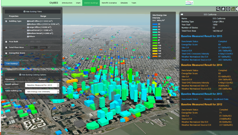
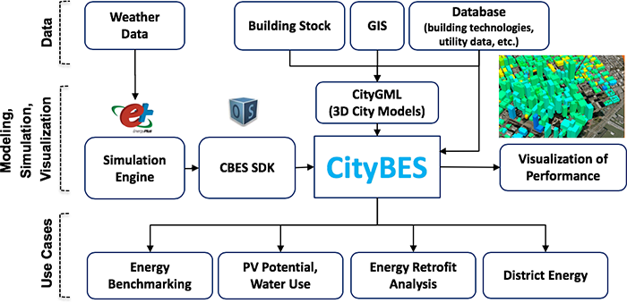
The following figure shows the three layers of the software architecture of CityBES: the Data layer, the Algorithms and Software layer, and the Use Cases layer. The Data layer includes the weather data, and the CityGML 3D city model. The Software layer includes EnergyPlus, OpenStudio SDK, CBES API, and CityBES. The Use Cases layer provides examples of applications, including energy benchmarking, PV (renewable power generation), water conservation, large scale energy retrofit analysis, district energy (under development), as well as building performance visualization.
More information about CityBES is available at CityBES.lbl.gov.
BRICR
BayREN Integrated Commercial Retrofits (BRICR) is a DOE funded project which aims to enhance the capacity of energy efficiency programs to recruit participants, develop retrofits, and measure outcomes in small and medium-sized commercial buildings, which is a sector notoriously hard to reach and expensive to serve, while accounting for two-thirds of U.S. commercial floor space.
To address these barriers, BRICR leverages existing incentives, financing, data, and open source software to facilitate two paths for comprehensive improvements:
- a deep energy retrofit
- or serial upgrades
The latter is intended to offer flexibility for retrofit plans to integrate with capital improvement and maintenance cycles.
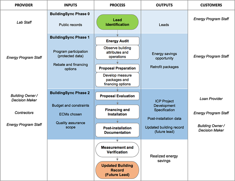
BRICR is prepared to field pilot a workflow for iterative energy modeling of commercial buildings — starting with mass building-scale simulation based on public records and proceeding through to audit, retrofit, and measurement of realized savings.
BRICR builds on existing tools including Berkeley Lab's CBES, National Renewable Energy Laboratory's OpenStudio, Pacific Northwest National Laboratory's Audit Template, and DOE's BuildingSync and SEED Platform™. At each stage, BRICR uses the level of detail available to inform simulations (initially with public records but iteratively augmented with observations from energy program staff) to improve the quality of the model that informs decision making.
More information on the BRICR project is available at www.energy.gov/eere/buildings/downloads/san-francisco-bayren-integrated-commercial-retrofits.
Open City Models
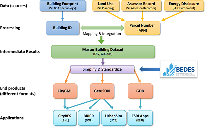
The first and a critical step of UBEM is to develop a digital representation of building stock in cities which contain hundreds of thousands of buildings. The Figure shows the workflow used to create the dataset of San Francisco building stock. The land use, assessor records, and energy disclosure databases use the Assessor Parcel Number (APN) as parcel identifiers to store the building data. We first consolidated the parcel-related data and mapped them with the building footprint data to create a master building dataset with all the fields from each dataset. Next, the master dataset was simplified and standardized to create 3D city models in CityGML for all the San Francisco buildings. The Building Energy Data Exchange Specification (BEDES) was used to standardize the terms in the building dataset. The final dataset products were provided in CityGML, GeoJSON, and FileGDB formats that can be used by various urban modeling and analysis tools.
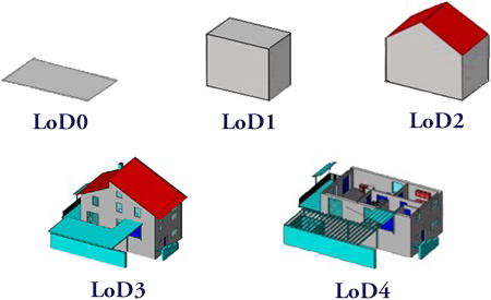
CityGML is an international Open Geospatial Consortium standard for the representation and exchange of 3D city models. CityGML defines the 3D geometry, topology, semantics, and appearance of urban objects, including buildings and their components, bodies of water, city furniture (street lighting, traffic lights), transportation infrastructure (streets, roads, bridges, tunnels), and vegetation. CityGML has the flexibility of representing urban objects at various levels of details. For example, a building has five levels of representation as shown in the figure.
This is an important feature as some buildings in cities have more information (e.g., those subject to city's energy benchmarking and disclosure ordinance) while others have minimal public information (e.g., use type, year built, total floor area). Along the way, more information becomes available for more buildings and can be added to improve the CityGML representation.
